 |
| Both of us got stung by Bee at the begining of our hikes and from stranger we become friends :) |
Gunung Angsi is located in Ulu Bendul Recretional Park, about 20km from Seremban, the capital of Negeri Sembilan. It is one of the minor mountain in Malaysia which has a height of 2702ft or 824m. Gunung Angsi is 3rd highest peak in Negeri Sembilan state after Gunung Datuk and Gunung Bintongan but 241st highest in Malaysia. Malaysia. It takes approximately 1.5 hour driving from Klang but only an hour from KL Town. The hiking distance via Ulu Bendul will take 8km for one-way but Bukit Putus routes only take half of it which is 4km for one way. Therefore, many said that via Ulu Bendul is a much challenging route.
This is my first time went hiking at Gunung Angsi, I decide to join a new friend - James who I met at Gunung Datuk in previous week together with his Muar Hiking Gang who he met during his previous hiking at Apek Hill. (what a small world?)

Since we have to gather with #muarhiking group who came all the way from Johor and some from Melaka at 7.00 am at the entrance of Gunung Angsi Starting point. I depart from my house at 5.00 am and reach James' house at 5.30 am. We decide carpool with James' car together with his another friend-Jessie. So, Jessy and Jessie go hiking with James and his gang.
Getting There (60 minutes from KL Town)

To enter Gunung Angsi, you have to pay a permit at RM5, as well we fill up our name, contact number, home address to prevent missing during our hike. Me, James and Jessie as well pay another RM11 for transportation via Bukit Putus route coming back to entrance when descending and also for the fee of two jungle guide who lead us via Ulu Bendul.
While waiting the rangers to lead us, we start our warm up session with Jason and introduce ourself to each other. Honestly, I am not able to remember all of them but I believe most of them must had remember me so well as result of bee incident.
 |
| Permit |
While waiting the rangers to lead us, we start our warm up session with Jason and introduce ourself to each other. Honestly, I am not able to remember all of them but I believe most of them must had remember me so well as result of bee incident.
 |
| Carpark via route Ulu Bendul |
As the clock strikes to 8.30 am, one of the rangers arrive and we decided not to wait for another and start of jungle trekking for the first hour.
For the first 2km, we walk through the trail beside a river and met a group of giant millipedes family. Although all of them looks about 20cm long and 3cm thick, in fact they are still baby because from the light color of their body.
After 5 minutes walk from baby millipede, we met this adult millipede and I called it "papa" (father) of those millipedes just now.
 |
| starting point via Ulu Bendul |
For the first 2km, we walk through the trail beside a river and met a group of giant millipedes family. Although all of them looks about 20cm long and 3cm thick, in fact they are still baby because from the light color of their body.
 |
| Giant Millipedes Baby |
 |
| Giant Millipedes Daddy |
We stopped at this pondok to gather with others team members also do our headcount before proceed together, and this is where my nightmare begins. After getting 5 minutes from this point, I passed by an area with flowers and bees which I do not take cautions about it. Without warning, I feel pains coming from near to my waist and another pain from my leg. When I realize it was already too late as the bee had attach on my leg and I have to hit it away and run in front to sit on a boulder.
There is another girl who also sitting in front having bee stung on her thigh and me is calf also my waist. It is so pain and my tears run a bit from my eyes but after apply balm I keep moving and cross over two stream hoping that I can forget the pain HAHA.
Until some points, James asked me whether I am OK which I still holding the pain and tears. Then one of the member ask me stop to check for my wound and also bring me the Panadol (pain and fever killer). Out of sudden, she press my wound at my back again both my eyes filled up with tears and this time it flows like a waterfall :( It is so shameful until today.
 |
| checkpoint via Ulu Bendul - Pondok |
About 1.5 hours from the pondok, you will see this "Lazy Log 2" sign and a signboard saying "7 MINS TO SUMMIT". Literally, we got fool by the 7 mins or maybe it should be 57 mins or 47 mins instead of just 7.
 |
| checkpoint via Ulu Bendul - Lazy Log 2 |
 |
| 7 MINS TO SUMMIT |
After 7 mins, we reach this point which require climbing skill using rope and where we start our real steep journey of 2km to reach the peak. The total ascending of this 2km reach almost 450m in total which Gunung Angsi only stand a height of 824m.
 |
| Result of 7 min to summit ** erhemm!!** |
 |
| Steeply uphill for 1 hour |
By moving slowly with minimum stop, we took about 1 hour from the "Lazy Log2" to reach the summit of Gunung Angsi. Photo session and lunch for celebration while waiting for another 2 team members.
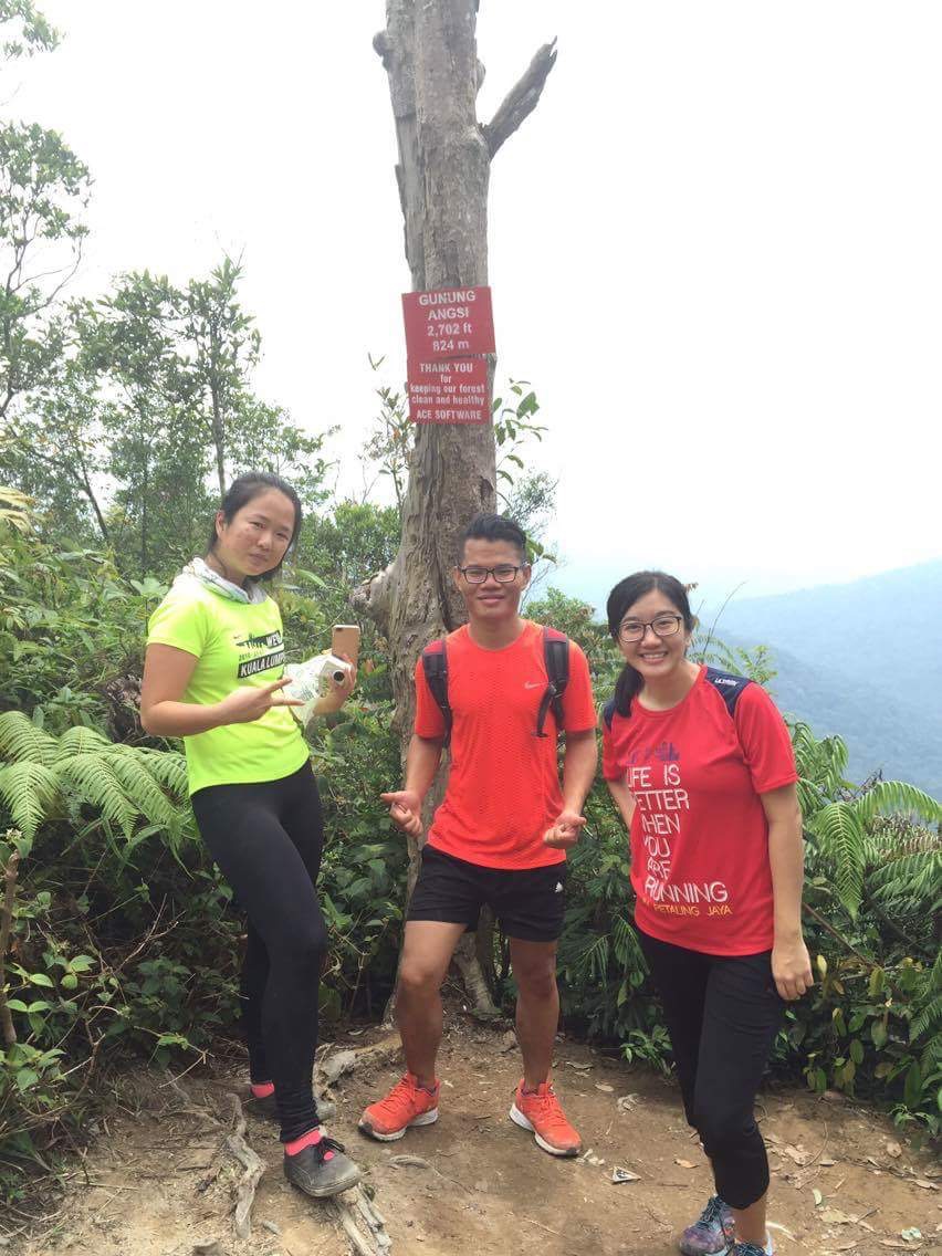 |
| Jessy - James - Jessie |
 |
| Pretty ladies and macho uncle |
 |
| Newly met people at the summit |
I met my "bee stung" buddy with her gang at the peak. After having group photo and rest for 1 hour, we take Bukit Putus route for descending.
About 20 minutes from peak, we reach a viewspot called "waterfall view" that couldn't found any waterfall view. However, it is still a good spot which worth to pause a break for photography.
 |
| Checkpoint 2 via Bukit Putus - "Waterfall view" |
We move on in 40 minutes later and pass by a small hut equipped with some cooking utensil. There is a few hikers were gathering around, we greet each other and continue to finish until the end.
 |
| Checkpoint 1 via Bukit Putus |
 |
| Does it looks like Nami Island from Korea? |
Finished our hike, we took the van with Muar Hiking Group back to our starting point to use the washroom clean up ourselves, they do collect a small fee of 20 sen/person for each entry.
Things to Prepare:
Water 1.5L (minimum)
Isotonic Drinks
Chocolate and energy bar
Salt/ Salt Mist (got leeches)
First Aids Kits/ Balm
Salt/ Salt Mist (got leeches)
First Aids Kits/ Balm
Proper hiking shoes
Hiking stick (recommended but optional)
Raincoat (optional)
Extra pair of shirts and pants for changing after hike
Starting Coordinates: 2.727418N ,102.0758E (Ulu Bendul)
Difficulty: Moderate to Hard
Average Completion Time: 5 hours (3.5 hours uphill via Ulu Bendul and 1.5 hours downhill via Bukit Putus route)
 |
| All Ladies :) |
 |
| The End with Muar Hiking |
If you have any questions, please feel free to drop them at the comment section below. Thank you! :)
Others:
Wah, I'm about to comment but some of your posts on the year 2016 and I had been to bukit batu putih for several times and last month hiked Gunung Datuk. I dont know if you will ever see this comment but I'm planning to bring my friends to hike Gunung Angsi next month but I kind of afraid about the marking trails as it will be my first time hiking there. Is the marking trails visible and hikers will easily reach the summit easily using the marking provided?
ReplyDelete